Understanding these precipitation types helps explain why weather forecasts distinguish between them and why some conditions are particularly dangerous. Freezing rain, for instance, poses greater hazards than snow because it creates icy road surfaces and can snap power lines under accumulated weight.
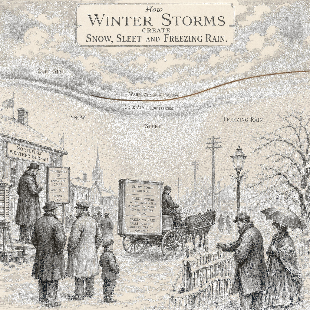
When major winter storms move in, they bring snow, sleet, freezing rain or extreme cold — but which type reaches the ground depends on how the atmosphere is layered.
How Atmospheric Layers Shape Precipitation
Snow forms when cold air extends consistently from the clouds to the surface. “The further north, the deeper that Arctic layer is, the more likely to support snow,” according to Judah Cohen, an MIT research scientist. Farther south, the atmosphere typically contains a sandwich of warm air between cold layers, which fundamentally changes what falls.
Sleet and freezing rain illustrate how critical this atmospheric layering is, though the two form through distinctly different processes. With sleet, snowflakes fall through a warm layer high above and melt, then encounter another cold layer near the surface and refreeze before hitting the ground, creating bouncy ice pellets. “The snowflakes form, they fall and then they meet a warm layer, a layer above freezing, and they will melt. But then there’s another layer near the surface that’s below freezing again, so they will refreeze before they hit the ground,” Cohen said.
Freezing rain develops through a different path. When the cold layer near the surface is too shallow for raindrops to refreeze in the air, they hit the ground as liquid water and freeze on contact, creating a slick coating that turns roads into skating rinks.
Graupel and Hail
Graupel is an intermediate form between snow and sleet. David Robinson, New Jersey’s state climatologist at Rutgers University, described it this way: “It’s snow that has tried to melt on its way down, but not quite melted. It’s out of that six-point crystalline shape and has begun to look more like a cotton ball. So it hasn’t gotten to the point of full melt that it could then refreeze as sleet.”
Hail is a distinctly different phenomenon that typically occurs in summer, not winter. Many people confuse it with sleet, but real hail requires warmer air closer to the surface that creates updrafts, allowing rain to move up, freeze, fall, and move up again, building layers of ice like an onion.
Winter Hazards and Safety Alerts
The different precipitation types carry different hazards. Snow is dangerous enough to cause accidents and whiteouts, but at least it can be plowed. Sleet’s icy composition makes removal much harder. Freezing rain is the most devastating because it transforms roadways into skating rinks and the accumulated weight can snap power lines.
When temperatures and wind chills drop to dangerous levels, the National Weather Service issues tiered alerts. A cold weather advisory signals that dangerous weather is likely. An extreme cold watch means life-threatening weather is possible. An extreme cold warning means life-threatening weather is likely.